

Mapping Power: How Politics and Corporate Power Redraw Our Maps
When you look at a map or visit a new place, how often do you stop to think about why it is named the way it is? What stories, histories, or decisions are behind those names? Maybe you think about it more now than ever, as places across the city and country are being renamed or having their original Indigenous names restored after generations of colonial naming. Or perhaps you have been thinking about it because of what the United States is doing: moving in the opposite direction.
As I’m sure you have heard by now, on August 27, 2026, U.S. President Donald Trump signed Executive Order 14422, titled "Honoring the American History of the Great Lakes and Renaming Lake Ontario as Lake America" (Federal Register, 2026). The retaliatory measure followed the breakdown of trade negotiations and Canada's implementation of counter-tariffs on U.S. imports (Chidi, 2026). While replacing Indigenous place names with nationalist branding is not new for the administration, following similar executive actions targeting the Gulf of Mexico and Denali (Financial Express, 2026), this move shows how political mandates can, in fact, attempt to overwrite centuries of history.
The name Ontario originates from the Wyandot/Wendat word Ontari'io, meaning "great lake" or "lake of shining waters," long predating both Canadian Confederation and the U.S. Declaration of Independence (Rukavina & Boyce, 2006).
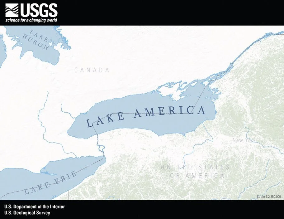
U.S. Geological Survey / U.S. Department of the Interior via Wikimedia Commons (Public Domain) https://commons.wikimedia.org/wiki/File:U.S._Geological_Survey_map_of_Lake_America.jpg

Because this executive order only legally binds U.S. federal agencies to update the Geographic Names Information System (GNIS), it carries no international legal authority over shared waters governed by the 1909 Boundary Waters Treaty (PBS NewsHour, 2026; Federal Register, 2026). In response, Canadian leaders flatly rejected the change, with Ontario Premier Doug Ford erecting a prominent "Lake Ontario. Now and Always" sign along the shoreline (Gillies, 2026). However, the real problems played out in the private tech sector.
Both Google and Apple quickly changed their U.S. map displays. Google Maps showed “Lake America” to users in the United States while continuing to show “Lake Ontario” to users in Canada; users outside both countries saw both names. Google attributed the change to its longstanding policy of using geographic names from the U.S. Geographic Names Information System (GNIS). Apple Maps subsequently made the same change for U.S. users, after Interior Secretary Doug Burgum said Trump had contacted Apple directly about the change (Associated Press, 2026).
Major tech executives, including former Apple CEO Tim Cook and leaders from Google's parent company Alphabet, previously contributed $1 million each to Trump's inauguration fund and have consistently sought to appease the administration to hedge against pending antitrust suits, federal regulations, and government contract disputes (Consumer Federation of America, 2025; CIVICUS Lens, 2025). By quickly updating the maps at the president's request without question, these platforms obviously prioritized political goodwill over geographical integrity.
While the compliance of Google and Apple showed just how easily private platforms can be leveraged as tools of state power, counter-movements quickly emerged. Legacy navigation app MapQuest openly defied the White House, posting "we're not changing it" on social media, leading to the app briefly surging to the number one spot in the U.S. App Store charts (Associated Press, 2026).
Overall, this makes me deeply question the everyday digital infrastructure we take for granted. Apple Maps and Google Maps dominate our lives. We rely on them daily for satellite imagery, transit routes, and navigation without a second thought. It is easy to view these platforms as neutral, objective public utilities, but they are ultimately private, multi-billion-dollar corporations driven by self-interest. When digital cartography can be changed to appease political leaders, even something as fundamental as a map is put at risk. If lines on a screen can be reshaped like this, we lose the shared, objective geographic truth needed to navigate the world around us.
Written by GAPSS VP Internal Logan Windebank
References
Associated Press. (2026, August 29). Ontario premier answers Trump's 'Lake America' with giant 'Lake Ontario' sign. AP News. https://apnews.com/article/60bf599146367923edb28dfc327edf98
Associated Press. (2026, September 2). Apple changes Lake Ontario name to 'Lake America' for U.S. users of its Maps, following Trump's order. AP News. https://apnews.com/article/14abb66fe0ecfa05bffd42fb083dc70d
Chidi, G. (2026, August 27). Trump signs executive order to rename Lake Ontario as Lake America. The Guardian. https://www.theguardian.com/us-news/2026/aug/27/trump-renames-lake-ontario-america
CIVICUS Lens. (2025, February 20). Tech leaders cosy up to Trump. https://lens.civicus.org/tech-leaders-cosy-up-to-trump/
Consumer Federation of America. (2025, October 15). Quid bro quo: Tracking how Big Tech and the Trump White House keep exchanging gifts. https://consumerfed.org/news/blogs/quid-bro-quo-tracking-how-big-tech-and-the-trump-white-house-keep-exchanging-gifts
Financial Express. (2026, September 10). Trump now wants 'New America': 4 places he tried to rename since returning to power. https://www.financialexpress.com/world-news/us-news/trump-now-wants-new-america-4-places-he-tried-to-rename-since-returning-to-power/4336026/
Gillies, R. (2026, August 29). Ontario premier answers Trump's 'Lake America' with giant 'Lake Ontario' sign. AP News. https://apnews.com/article/60bf599146367923edb28dfc327edf98
Office of the Federal Register. (2026, September 2). Honoring the American history of the Great Lakes and renaming Lake Ontario as Lake America (Executive Order No. 14,422). Federal Register, 91, 56543–56544. https://www.federalregister.gov/documents/2026/09/02/2026-18020/honoring-the-american-history-of-the-great-lakes-and-renaming-lake-ontario-as-lake-america
PBS NewsHour. (2026, August 27). News Wrap: Trump signs order to rename Lake Ontario. PBS. https://www.pbs.org/video/august-27-2026-pbs-news-hour-full-episode-1787803201/
Rukavina, N., & Boyce, F. M. (2006). Lake Ontario. The Canadian Encyclopedia.
Image credit: U.S. Geological Survey / U.S. Department of the Interior via Wikimedia Commons (Public Domain) https://commons.wikimedia.org/wiki/File:U.S._Geological_Survey_map_of_Lake_America.jpg
Cover photo image credit: Official White House Photo by Molly Riley via Wikimedia Commons (Public Domain) https://commons.wikimedia.org/wiki/File:Executive_Order_renaming_Lake_Ontario_to_Lake_America,_August_27,2026-_4.jpg
